Hazardous Environments - 3.1 (Tropical Cyclones, Hurricanes and Typhoons; Earthquakes and Volcanoes)
Tropical Cyclones, Hurricanes and Typhoons
What is the difference between the three?
Cyclones are formed in the Indian Ocean, hurricanes in the Middle Atlantic and typhoons in the Pacific Ocean.
Cause:
Start when high temperatures cause air to rise from the surface of the sea. The rising air causes local thunderstorms, and sometimes these storms come together and create a strong flow of warm, rapidly rising air, creating an area of increasingly low pressure.
(Applies to hurricanes + typhoons as well)
- Ocean water must be 26 degrees celsius and at least 50 metres deep to form a cyclone/hurricane/typhoon.
Characteristics
- Have very low pressure
- Often 600-900 km across
- Bring torrential rain, thunder, lightning, and strong winds
- Can cause widespread damage
- On average last for 10 days, but can last for up to 4 weeks
- Have to form on large bodies of water
- Don't remain where formed. They follow the direction of prevailing winds and ocean currents
- The further they travel over water, the more energy they gather from warm ocean waters
- When they reach land, energy supply is cut off, so they lose strength moving more and more slowly until dying
Coriolis Effect
- A phenomenon that causes fluids like water and air to curve as they travel across the Earth. It makes storms move in a clockwise direction in the Southern hemisphere and anti-clockwise in the Northern Hemisphere.
Measurement
Saffir-Simpson Scale
Earthquakes and Volcanoes
Causes
Tectonic Plates:
- Rigid blocks that make the Earth's surface move over the surface of the Earth creating earthquakes and eruptions.
- Constructive: Two plates pull apart, creating a constructive or divergent margin. Magma rises to the crust to fill the gap and created new crust through volcanoes. Also called divergent.
- Destructive: Two plates meet and one plate margin is destroyed as it plunges beneath the other plate. Molten rocks rise to create volcanoes and the friction causes earthquakes. Also called convergent or subduction.
- Collision: Two plate margins of equal density and strength meet. The sediments between them are squeezed up. The results is fold mountains and earthquakes causes by the pressure and friction.
- Conservative: Two plates slide past each other. Since there is no rising magma or subduction, there are no volcanoes. Instead, the friction causes earthquakes. Also called transform.
Hotspots:
- Locations beneath the Earth's crust where strong and rising currents of magma (plumes) occur. Where the crust above a plume is weak, volcanic activity occurs.
 |
Distribution
- Occur along tectonic plate boundaries
- There is a concentration of volcanoes along the destructive plate margins that fringe the Pacific Ocean, which also has a lot of earthquakes
- There are a lot of earthquakes along the African Rift Valley, but not many volcanoes
Characteristics
Volcanoes

- Gas emissions - sulphur, carbon dioxide and cyanide. Being dense, they keep close to the ground. Lethal ones (particularly) are called pyroclastic flows.
✩ Lahars - A flow of wet material from volcanic ash
- All of the things labeled in the diagram are characteristics of volcanoes when they erupt.
Earthquakes

- The closer to the epicentre, the greater the damage. The farther, the less severe the damage.
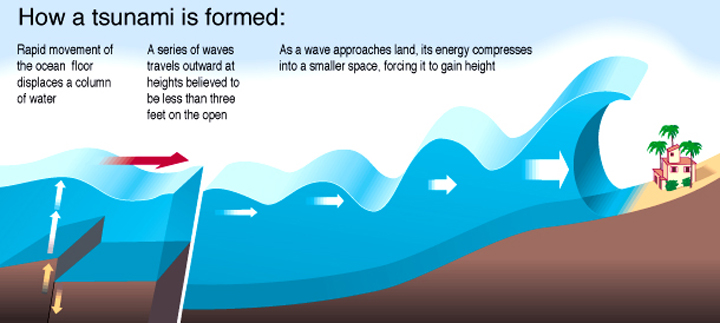
- For tsunamis, underwater earthquakes lift water up, forming waves upwards. Then, waves meet the continental slope and individual waves spread out, hitting the coast.

Measurements
Volcanoes
- Right now, VEI (Volcanic Explosivity Index) is the most widely used method of measuring eruptions; it measures the intensity of logarithms scale of 1-8 but it is only suited to the assessment of historic eruptions.
- Seismometers are used to measure earthquakes near an eruption, titlemeters and GPS satellites are to monitor changes in landscape, gases escaping volcanoes are monitored, temperature is measured.
Earthquakes
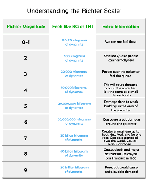
- Richter scale measures an earthquake's strength according to the amount of energy released, using a seismograph, running from 2.4 to 8.0.
- Is it logarithmic, meaning that one point up on the scale represents a 30x increase.
- The Mercalli Scale is quite different; it is based on what people experience and the amount of damage done.
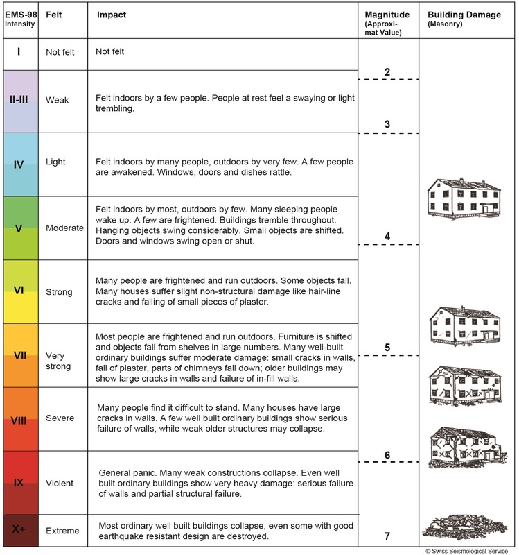 |
| Mercalli Scale |
- The Moment Magnitude Scale (MMS) was introduced in 1779, and it measures the amount of energy released on a logarithmic scale, but its assessment is based on the amount of rock movement along and around a fault or fracture.


Comments
Post a Comment